
Routes on mountaineering expeditions are not as straightforward as they may appear. Only those who have completed their professional training as part of the Basic Mountaineering Course or have significant experience in high altitude trekking and rock climbing are eligible to embark on mountaineering expeditions, and for good reason. A variety of terrain is encountered on these routes and it is crucial that one knows how to navigate and traverse through such terrains. Special equipment might be needed to navigate through certain types of terrain. It also helps to be familiar with the terminology of different kinds of terrain in higher altitudes. As you keep climbing higher, you will notice a gradual change in the landscape around you. The greens start to fade and the greys and blacks start taking over the scenery.

In this article, we lay out and define the different geographical features and terrain that you will encounter on a mountaineering expedition along with information on how best to navigate them and the kind of equipment needed for the same.

The Terrain Beyond the Treeline
You would have noticed on a high altitude trek or even while driving to places above 10,000 ft. that the landscape is not what it was when you started off. The green pine forests have slowly started to decline and a drier, rockier terrain has taken over. This elevation at which trees stop to grow is referred to as the treeline. At this height, the temperatures are too cold and dry to support plant life. There is an increasing presence of boulders, broken rocks and moraine at these altitudes, making the overall atmosphere dry and dusty. As you go further up, snow is commonly found during the winters and is even perennially present in some places. The water streams that you frequently encounter in greener meadows or forests will be fewer and could even be frozen depending on the prevailing temperature in the region. These features make it more difficult to traverse in higher altitudes without adequate training and suitable equipment. It is important to be aware of these changes in terrain and know what awaits you on challenging treks and expeditions.


Terminology of Geographical Features on Mountaineering Expeditions
Crevasses
These refer to deep cracks that form in ice sheets or glaciers, with their width varying from a few inches to over 40 ft. They usually form in the top parts of the glacier, where the ice is brittle. Crevasses can go as deep as 150 ft and often have vertical or near-vertical walls. The size of the crevasse depends on the quantity of liquid water present in the glacier. They make glacier crossings extremely tricky as they are often rendered invisible by old snow bridges that cover but do not fill up the crevasse. Teams crossing glaciers should use their ice axe or ski poles to probe the area for a change in the resistance of the snow. Techniques for navigating crevasses include walking around them, crossing them on ladders or stable snow bridges, or even jumping over them if they are not too wide. All these techniques and equipment use requires thorough training and should not be attempted otherwise.

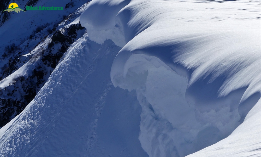
Serac
Seracs are towers or pinnacles of ice that are found in large numbers at the edge of ice cliffs and ice falls. Their unstable nature makes them dangerous and unsuitable for climbing. They fall off periodically and with little warning. It is advisable to avoid climbing directly under a serac, although it could be the best possible route on some mountains. It then becomes important to time your climb in such a way to avoid being under a serac for too long and cross it at a time when the snow and ice are rigid from the cold temperatures.

Overhang
Overhangs are ice walls or rock faces with a gradient of more than 90 degrees. Climbing aids are indispensable for overhangs in alpine style climbing. Ropes and jhumars play a key role in facilitating the climb up an overhang.

Moraine
Moraine is a combination of stone and other debris found at the centre, sides, bare or snout of a glacier. It consists of boulders, old ice, and mud, all crushed by the glacier’s movement which creates a grinding action. Traversing through moraine could be challenging if you are unaware of the techniques and safety procedures. Keep your crampons handy while walking through moraine. Be wary of mud covered ice, test the area with a pole or ice axe before settling foot. Avoid placing your foot below big rocks and boulders, the shifting and melting of ice could leave a lot of them loose.

Scree
Scree refers to the accumulation of loose rock that has eroded from the mountain and is found on steep slopes. It is difficult to ascend and descend through scree with the loose rock making it difficult to get a firm grip on the ground. Use trekking poles to aid your climb and descent on scree slopes. During the climb, let your foot sink in and get a firm grip before placing your next foot. While descending on a scree slope, deploy the heel-plunge: point your toes up and sink your heel in first.

Cornice
These can be found built up on the ridge lines on the leeward side of mountains. They are typically overhanging masses of hard snow. Cornices are extremely dangerous and climbing above or below them should be avoided. During periods of high solar irradiance, cornices are susceptible to breakage and they usually trigger avalanches with their fall. When a cornice breaks, it collapses from the cornice all the way to the top of the peak, exposing climbers to hazards. It is safe mountaineering practice to stay far enough away from the edge so as to not be able to view the drop to avoid getting caught in a situation of a collapsing cornice.
Avalanche Prone Areas
These are regions which experience frequent avalanches owing to different environmental factors including the shape of the slope, angle of the slope and falling cornices among others. An increasing gradient of the slope is directly proportional to the possibility of an avalanche.

Gradient
Gradient refers to the angle of slope and helps determine how steep a slope is in terms of a given horizontal distance and the vertical change with respect to it. It is important to understand the gradient of a slope that you are climbing in order to be able to ascertain the best possible route, possible hazards and equipment that will be needed to scale the slope.

Gully
This is a narrow valley with steep sides caused by movement of water and other masses, creating an erosion in the surface of a mountain. Gullies are relatively easier to traverse (although could be technical and tricky depending on the geography) and do not require the use of any specialised equipment. Depending on the gradient of the gully, an ice axe and crampons usually suffice for a gully climb. On a steeper gradient, other climbing equipment such as ropes, jhumars and ice hammers will come in handy.

Rock Fall
Rock fall refers to the freefall of a single or multiple rocks over a slope or cliff by sliding or toppling along the way. Rock falls are common around glaciers with the melting ice shifting and loosening the rocks. Helmets are mandatory while traversing in regions prone to rock fall and it is advisable to be wary of every step to avoid setting off a rock fall or even getting caught in one.

Ice Wall
These are long vertical walls of ice that are found higher up in the mountains. They are challenging to climb given that there is no support system offered by the ice wall. Ropes, pitons, jhumars, harnesses and other safety equipment are absolutely necessary to scale an ice wall.

While these are some of the most common geographical features encountered on mountaineering expeditions, there are a few other terms you might hear during your training or from your trek leaders on high altitude treks. Tackling or traversing through such geographies and terrains is only possible after rigorous physical training and technical knowledge of how to use mountaineering equipment which is usually taught in the Basic and Advanced Mountaineering Courses. If you wish to know more or have further questions, our team would gladly provide you with further information on the topics discussed above.


")